
|
Created
|
 |
|
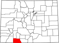
This county, named in honor of J. M. Archuleta, Sr., head of one of the old Spanish families of New Mexico, was taken from the western part of Conejos County, and duly organized under an act of the General Assembly, approved April 14th, 1885, the capital being located at Pagosa Springs. It is bounded on the north by Hinsdale and Rio Grande, south by New Mexico, east by Conejos and west by La Plata. Its area is 1,100 square miles, and by the census of 1890 its population was 826. In natural configuration, advantages and resources, it is much like La Plata County. The eastern, southern and parts of the western divisions are mountainous, with broad valleys and parks between, which are admirably adapted to cattle and sheep grazing. The mountains are densely timbered with white and yellow pine, cedar and spruce, from which large quantities of lumber are produced. It is splendidly watered by the Rio San Juan, Piedra Navajo, Blanco and Nutria rivers, all large, clear and beautiful streams. The Rio Conejos heads in its mountains; much of the valley appears to be underlaid with good bituminous coal, and there are numerous petroleum springs near the county seat. For years the farmers and others have used the oil products that lie at the surface for lubricating the axles of their wagons. The two principal parks are the Piedra and Weeminuche, which contain thousands of acres of fine agricultural and grazing lands, forming one of the most desirable regions for stock growing to be found in the southwestern division of the state. The assessment roll for 1890 places the number of cattle feeding upon these lands at 3,509; sheep, 17,840, and in addition there were about 1,000 horses. It never has been a populous nor an extensively cultivated farming region. Most of the settlers, to within a very recent period, were Mexicans, who settled along the streams while it was a part of Conejos county. Since its organization as a distinct county, many Americans have located there, and engaged in various pursuits. The report of the assessor for 1890 shows that only 5,693 acres of agricultural land were returned in that year, but there were 86,000 acres of grazing land. Archuleta is situated to the west of the San Juan range, at an elevation of 5,000 to 7,000 feet. Pagosa Springs, the capital, situated on the north side of the San Juan river, is the only town of importance in the county, and is one of the most noted sanitariums of the state. Here are found some twenty hot springs, the largest, or the "Great Pagosa," being oval shaped, 50x74 feet, and of unknown depth. The temperature near the edge is 145 degrees and in the center 153 degrees. The following extract is taken from an account published in 1891, furnished me by Mr. E. M. Taylor, the county clerk. These wonderful springs "were first discovered by the United States exploring expedition, under command of J. N. Macomb, Captain of the Topographical Engineer Corps, U. S. A., in the month of July, 1859." It may be well to observe, however, that for centuries, perhaps, the Utes and other Indians had known of and frequently resorted to them for the cure of rheumatic and other ailments. Owing to the great value of the water on account of its medical properties, and the mammoth size of the "Great Spring," the President of the United States (in accordance with acts of Congress passed March 3d, 1863, and July ist, 1864) issued an order, during the year 1880, designating one mile square surrounding the principal spring as a United States government town site. In the year 1883 it was platted by the government into streets, avenues, blocks, building lots, large parks and boulevards. In 1885 the building lots were appraised by the U. S. Commissioners and sold from the land office of that district, as appraised government land is sold, to the highest bidder for cash. Since then the town has continued improving, and in 1891 was incorporated, and elected its first mayor and other officers. Now settlers are coming in and taking up government land. Surveys have been made for a railroad from Juniata, up the valley of San Juan river, to Pagosa, a distance of 20 miles. The San Juan river, one of the finest streams in the state, flows through the town site. "The overflow from the hot spring, emptying into the river, is equal to a stream six feet wide by three feet deep." The waters, heavily charged with carbonic acid gas, boil and bubble like the witches' cauldron in Macbeth, emitting clouds of vapor which, as one writer expresses it, "produces the smell of the infernal regions." The prevailing opinion is that this turbulent, odorous Pagosa is the remains of an old geyser. Geologists find here interesting subjects for study. Some remarkable cures have been effected by drinking and bathing in its waters. One of the conductors on the Durango division of the Denver & Rio Grande railroad informed me that for many years he had been rendered well nigh helpless by acute rheumatism in his right hip, and that the flesh had shrunk away so that only the skin adhered to the bone. His left leg was so stiff he could not use it. Advised to try Pagosa, he went there and in a short time was completely cured. Each year hundreds of invalids resort to these springs, and while not all are cured, a large majority are greatly benefited and many restored to health. Chronic rheumatism, sciatica, stomach disorders, blood and kidney diseases have been permanently relieved. Military and other officers of the government have sent many patients there. These springs are 400 miles southwest from Denver, and 280 miles from Pueblo. The nearest railway station is Amargo, a small settlement on the Rio Grande railroad, in New Mexico, just south of the Colorado line, 28 miles away. Passengers, mail and express are conveyed thence to the springs by stage. The climate is mild and exhilarating, the scenery thereabout very beautiful. The great peaks of the San Juan Mountains lie to the northward. To the east and west are the verdure and forest-clad plains of the valley, stretching far away into New Mexico. The springs and bath houses are the property of a Leavenworth, Kansas, company. In the pleasant seasons many people bring tents and camp in the groves along the San Juan river, while undergoing treatment. The town is headquarters for stock and wool growers, and a trading point for farmers. Iron ores, many varieties of sandstone, coal, petroleum, and gold and silver bearing minerals are among the known resources, but remain to be developed. About one-quarter of the county is covered by the Southern Ute Indian reservation. A further account of these Indians, their reservation, etc.. will be found in the history of La Plata county. The school census of Archuleta county for 1890 shows a total school population of 175. The enrollment was 99, with an average daily attendance of 46. There are three school houses which cost $5,450. In 1888 district No. i erected a fine building in modern style at a cost of $3,000. In 1887 district No. 2 furnished a small but good building at a cost of $1,500. District No. 3, built at a later date, cost $1,400. The first officers of the county were: Clerk, E. M. Taylor; treasurer, Isaac Code; county judge, J. H. Voorhees; assessor, J. P. Archuleta; sheriff, Wm. Dyke; coroner. Dr. N. Hover; superintendent of schools, F. A. Beyone; surveyor, C. Y. Butler; clerk of the district court, E. M. Taylor; commissioners, J. H. Hallett, A. S. Sutton, J. M. Archuleta, Jr. Those elected for 1890-91 were: Clerk, E. M. Taylor; treasurer, John L. Dowell; county judge, Barziilai Price; assessor, Chas. H. Loucks; sheriff, J. H. Hallett; coroner, Dr. Wm. M. Parish; superintendent of schools, Wm. P. Underwood; surveyor, Jas. S. Hatcher; clerk of the district court, E. M. Taylor; commissioners, R. J. Chambers, Wm. Dyke and Joseph Whitaker. The county is attached to the Durango land district. The Fort Lewis military reservation of 20,000 acres was opened to homestead settlement in 1890. The assessed valuation of taxable property in the county for 1890 was $368,334.70. For 1891 it was $418,681. The first settlers at Pagosa Springs, who located there in 1876, were Joseph Baker, L. Hamilton, E. C. Laithe, John Swartz, John R. Crump, John L. Dowell, F. A. Beyone, Joseph Lane and W. W. Nassaman. The first house was built by Jacob Scheifeer.
History of the State of Colorado, Embracing Accounts of the Pre-historic
by Frank Hall, Rocky Mountain Historical Company - Colorado - 1895 Pages 69-71 |
Archuletta County |
||
|---|---|---|
Trouble in Pagosa Springs - 1887 |
Biographies |
|
Newspaper Clippings |
Obituaries |
|
Archuleta County Resources - USGW Archives - Plus |
||
Cemeteries |
Marriages1886 - 1900 |
|
Census
|
Military
|
|
Court Records1934 Jury Pool Listing Immigration and Naturalization Court Case Index 1885 - 1925 Inheritance Records 1935 - 1953 |
Tax Lists1890 1891 1892 1893 1894 1895 1896 1897 1905 |
|
Directories - 1911Arboles Carracas Chromo Dyke Juantia Pagosa Junction Pagosa Springs Piedra |
MiscellaneousColorado Tombstone ProjectColorado Historic Newspapers Archuleta County Offices Archuleta County - Wiki 1922 Archaeological dig at Chimney Rock |
|


|
Loading
|
| You are visitor |